


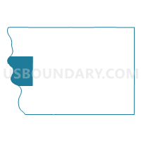
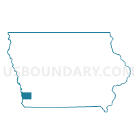
PLATTVILLE TWP Voting District, Mills County, Iowa
About
Outline

Summary
| Unique Area Identifier | 582833 |
| Name | PLATTVILLE TWP Voting District |
| County | Mills County |
| State | Iowa |
| Area (square miles) | 25.64 |
| Land Area (square miles) | 24.89 |
| Water Area (square miles) | 0.75 |
| % of Land Area | 97.08 |
| % of Water Area | 2.92 |
| Latitude of the Internal Point | 41.03971070 |
| Longtitude of the Internal Point | -95.83251380 |
Maps

Graphs
Select a template below for downloading or customizing gragh for PLATTVILLE TWP Voting District, Mills County, Iowa


Neighbors
Neighoring Voting District (by Name) Neighboring Voting District on the Map
- GLENWOOD TWP W/O GLENWOOD Voting District, Mills County, IA
- La Platte 2 Precinct, Sarpy County, NE
- LYONS TWP Voting District, Mills County, IA
- North Plattsmouth Precinct, Cass County, NE
- OAK TWP Voting District, Mills County, IA
- South Plattsmouth Precinct, Cass County, NE
- ST. MARYS TWP Voting District, Mills County, IA
Top 10 Neighboring County Subdivision (by Population) Neighboring County Subdivision on the Map
- Glenwood township, Mills County, IA (6,486)
- Plattsmouth precinct, Cass County, NE (3,095)
- LaPlatte I precinct, Sarpy County, NE (2,896)
- Oak township, Mills County, IA (2,501)
- Plattville township, Mills County, IA (849)
- Lyons township, Mills County, IA (247)
- St. Marys township, Mills County, IA (121)
Top 10 Neighboring Place (by Population) Neighboring Place on the Map
Top 10 Neighboring Unified School District (by Population) Neighboring Unified School District on the Map
- Glenwood Community School District, IA (11,146)
- Plattsmouth Community Schools, NE (9,716)
- South Sarpy District 46, NE (7,906)
Top 10 Neighboring State Legislative District Lower Chamber (by Population) Neighboring State Legislative District Lower Chamber on the Map
Top 10 Neighboring State Legislative District Upper Chamber (by Population) Neighboring State Legislative District Upper Chamber on the Map
- State Senate District 49, IA (60,560)
- State Senate District 45, NE (35,306)
- State Senate District 2, NE (35,052)
Top 10 Neighboring 111th Congressional District (by Population) Neighboring 111th Congressional District on the Map
- Congressional District 2, NE (638,871)
- Congressional District 1, NE (626,092)
- Congressional District 5, IA (577,453)
Top 10 Neighboring Census Tract (by Population) Neighboring Census Tract on the Map
- Census Tract 9661, Cass County, NE (4,505)
- Census Tract 9656, Cass County, NE (3,706)
- Census Tract 402.02, Mills County, IA (3,485)
- Census Tract 102.08, Sarpy County, NE (2,921)
- Census Tract 402.01, Mills County, IA (2,283)